
FREE SHIPPING ON ORDERS OVER $150*

AUSTRALIAN FAMILY OWNER FOR OVER 40 YEARS

100% SATISFACTION GUARANTEED


Garmin Echomap Ultra 2 105SV GN+ GT56 Fish Finder Sounder
$2,699.00$2,699.00$2,999.00

-

- 90 day returns

-

- Live & accurate stock levels shown on our website

-

- Safe & secure payment methods

-

- Australia’s cheapest prices

-

- Over 5,000 verified 5 star customer reviews

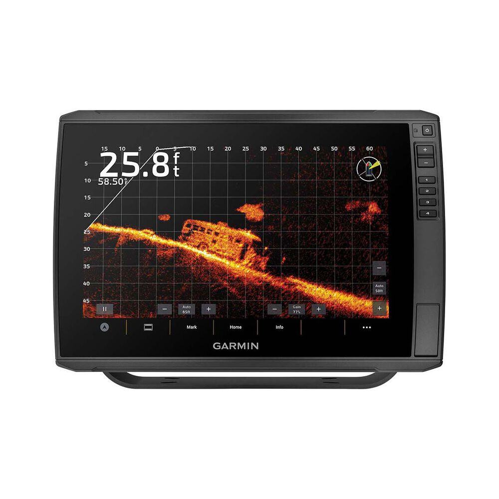
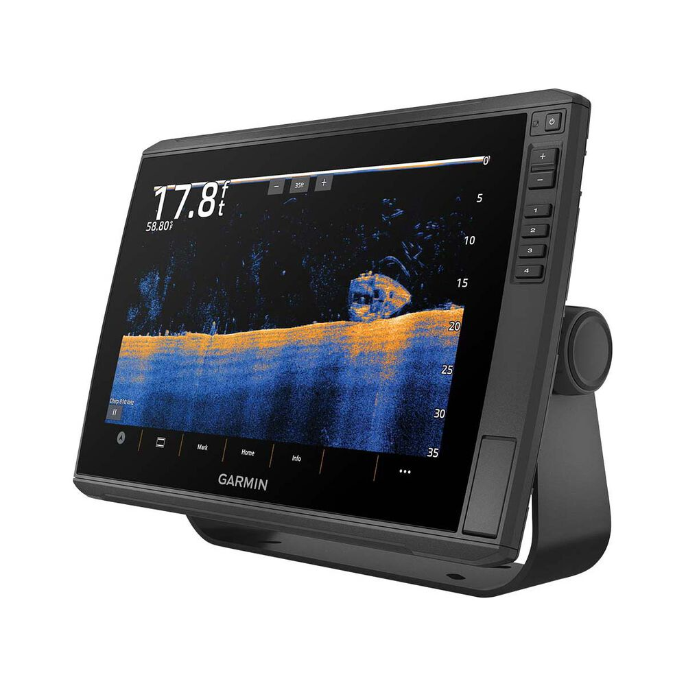
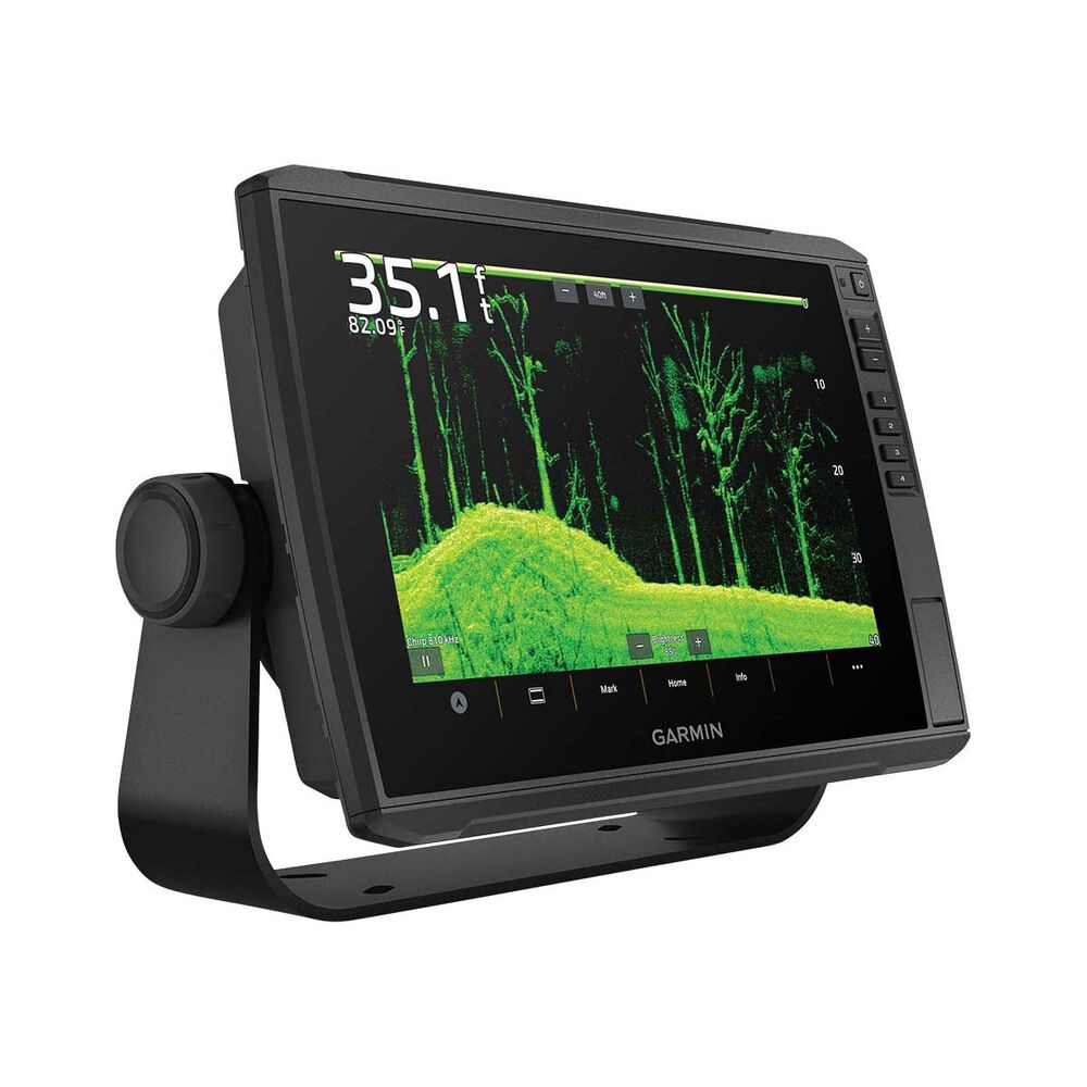
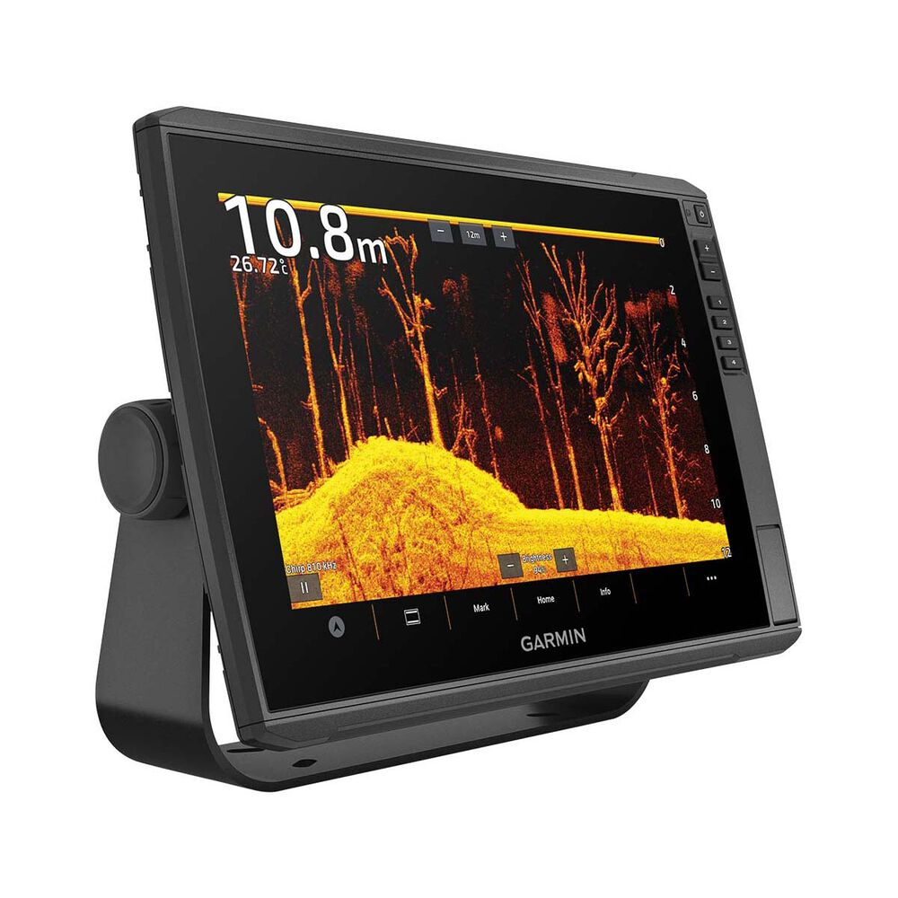
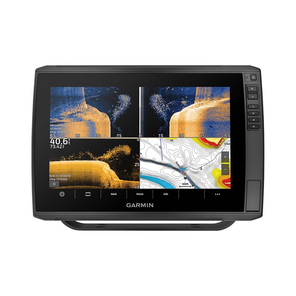
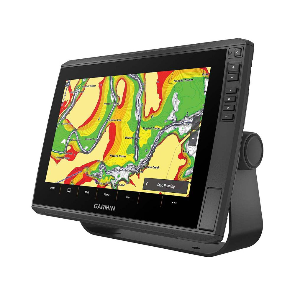
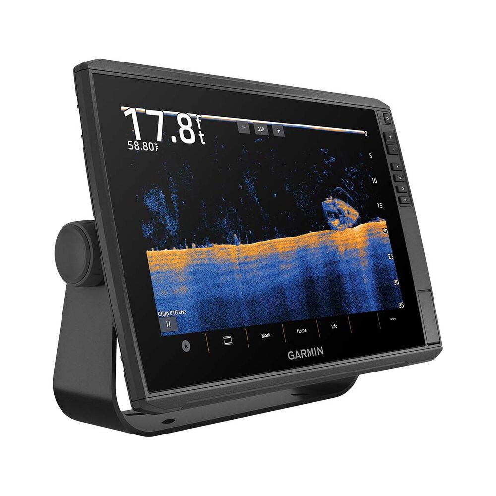
Equipped with large, clear, easily readable touchscreen displays, these multifaceted chartplotters offer a range of advanced fishfinding tools. The ECHOMAP Ultra 2 series allows for the use of LiveScope live-scanning sonar products (transducers sold separately). Some models also include a GT56 transducer with Garmin CHIRP traditional sonar and Ultra High-Definition ClearVü™ and SideVü™ scanning sonars, providing photo-like images of the underwater environment. High-contrast vivid color palettes make it easy to distinguish targets and structures. Enjoy unmatched coverage and detail. Certain units are equipped with built-in Garmin Navionics+ mapping, which comes with a 1-year subscription for daily updates, depth range shading, and more. Add a fresh new look and feel to your chartplotter with optional Garmin Navionics Vision+™ premium mapping (sold separately), featuring high-resolution relief shading, satellite imagery, and more.
Includes:
- ECHOMAP Ultra 105sv
- GT56UHD-TM transducer
- Charging/data cable
- Bail Mount With Quick Release Cradle
- Protective sun cover
- Hardware
- Documentation
![]()
Multi-band gps
Get improved position accuracy with multi-band GPS![]()
NMEA 2000® NETWORK COMPATIBILITY
Connect to heading sensors, autopilots, Fusion-Link™ audio systems and more.![]()
ActiveCaptain® App
Pair with the free smart-device app for software updates, screen recording, Garmin Quickdraw community data and more.![]()
Force® Trolling Motor
Wirelessly connect to your Force trolling motor to navigate to waypoints, draw and follow routes, and more.![]()
TAKE IT WITH YOU
The quick-disconnect bail mount lets you quickly install and remove your unit.
Specifications
General
| Dimension | 29.5 x 19.5 x 9.8 cm (11.6″ x 7.7″ x 3.9″) |
|---|---|
| Weight | 1.8 kg (4 lbs) |
| Water Rating | IPX7 |
| Touchscreen | Yes |
| Display Type | WXGA, IPS |
| Display Size | 21.7 x 13.6 cm; 21.7 cm diagonal (8.5″ x 5.4″; 10″ diagonal) |
| Display Resolution | 1280 x 800 pixels |
| Mounting Options | Bail or flush |
| Input | Touchscreen with Keyed Assist |
Maps and Memory
| Accepts Data Cards | 2 microSD Cards |
|---|---|
| Waypoints | 5000 |
| Track points | 50,000 |
| Tracks | 50 saved tracks |
| Navigation Routes | 100 |
Sensor
| GPS | Yes |
|---|---|
| GLONASS | Yes |
| Galileo | Yes |
| BeiDou | Yes |
| Has built-in receiver | Yes |
| Receiver | 10 Hz |
| NMEA 2000 Compatible | Yes |
| Supports WAAS | Yes |
|
Supports multi-bandmulti-constellation GPS |
Yes |
Built-in Maps
| Built-in Auto Guidance+ | Yes |
|---|---|
| Garmin Navionics+ Inland & Coastal | Yes (see Additional) |
| Tide tables | Yes (see Additional) |
Optional Map Support
| BlueChart g3 | Yes |
|---|---|
| BlueChart g3 Vision | Yes |
| Garmin Navionics+™ | Yes |
| Garmin Navionics Vision+™ | Yes |
| TOPO 100K | Yes |
| Standard Mapping | Yes |
| Garmin Quickdraw Contours | Yes |
Chartplotter
| AIS | Yes |
|---|---|
| DSC | Yes |
| Supports Fusion-Link™ compatible radios | Yes |
| ActiveCaptain Mobile Planning Compatible | Yes |
| Sailing Features | Yes |
Electrical
| POWER INPUT | 9 to 18 Vdc |
|---|---|
| Typical current draw at 12 Vdc | 2.3 A |
| Maximum current draw at 12 Vdc | 5 A |
| Maximum power usage at 10 Vdc | 34 W |
Sonar
| Displays sonar | Yes |
|---|---|
| Power output | 600 W |
| Traditional sonar (dual frequency/beam) | built-in (single channel CHIRP, 70/83/200 kHz, L, M, H CHIRP) |
| ClearVü | Built-in 260/455/800/1000/1200 kHz |
| SideVü | Built-in 260/455/800/1000/1200 kHz |
| Panoptix™ sonar | Yes |
| LiveScope | Yes |
Connections
| NMEA 2000® ports | 1 |
|---|---|
| Garmin Marine Network Ports | 2 (large connector) |
| 12-pin transducer ports | 12-pin scanning sonar |
| ANT+ (Connectivity) | Yes |
| Garmin Wi-Fi network (local connection) | Yes |
Get your Garmin Echomap Ultra 2 105SV GN+ GT56 Fish Finder Sounder in 3 Simple Steps
-
1
Shop Securely
Place an order with confidence using our secure checkout process
-
2
Order Processing
Allow our warehouse team some time to process your order. Receive order updates via email throughout the process
-
3
Enjoy your gear!
Join over 100,00 other happy Davo's customers. Let us be by your side for all your fishing and outdoors pursuits

About Davo's Tackle


Davo's Tackle and Outdoors Online has become a brand that is synonymous with a range of Fishing and Outdoors products that is second to none; at the sharpest pricing available globally.


Free shipping over $150 excluding bulky items


90 day returns


Fast & Secure payment options


Heavy discounts on big brands


Reputable Australian online retailer


Australian owned for over 40 years


Fish now and pay later


Accurate stock shown on our site
$2,699.00$2,699.00$2,999.00
Equipped with large, clear, easily readable touchscreen displays, these multifaceted chartplotters offer a range of advanced fishfinding tools. The ECHOMAP Ultra 2 series allows for the use of LiveScope live-scanning sonar products (transducers sold separately). Some models also include a GT56 transducer with Garmin CHIRP traditional sonar and Ultra High-Definition ClearVü™ and SideVü™ scanning sonars, providing photo-like images of the underwater environment. High-contrast vivid color palettes make it easy to distinguish targets and structures. Enjoy unmatched coverage and detail. Certain units are equipped with built-in Garmin Navionics+ mapping, which comes with a 1-year subscription for daily updates, depth range shading, and more. Add a fresh new look and feel to your chartplotter with optional Garmin Navionics Vision+™ premium mapping (sold separately), featuring high-resolution relief shading, satellite imagery, and more.
Includes:
- ECHOMAP Ultra 105sv
- GT56UHD-TM transducer
- Charging/data cable
- Bail Mount With Quick Release Cradle
- Protective sun cover
- Hardware
- Documentation
![]()
Multi-band gps
Get improved position accuracy with multi-band GPS![]()
NMEA 2000® NETWORK COMPATIBILITY
Connect to heading sensors, autopilots, Fusion-Link™ audio systems and more.![]()
ActiveCaptain® App
Pair with the free smart-device app for software updates, screen recording, Garmin Quickdraw community data and more.![]()
Force® Trolling Motor
Wirelessly connect to your Force trolling motor to navigate to waypoints, draw and follow routes, and more.![]()
TAKE IT WITH YOU
The quick-disconnect bail mount lets you quickly install and remove your unit.
Specifications
General
| Dimension | 29.5 x 19.5 x 9.8 cm (11.6″ x 7.7″ x 3.9″) |
|---|---|
| Weight | 1.8 kg (4 lbs) |
| Water Rating | IPX7 |
| Touchscreen | Yes |
| Display Type | WXGA, IPS |
| Display Size | 21.7 x 13.6 cm; 21.7 cm diagonal (8.5″ x 5.4″; 10″ diagonal) |
| Display Resolution | 1280 x 800 pixels |
| Mounting Options | Bail or flush |
| Input | Touchscreen with Keyed Assist |
Maps and Memory
| Accepts Data Cards | 2 microSD Cards |
|---|---|
| Waypoints | 5000 |
| Track points | 50,000 |
| Tracks | 50 saved tracks |
| Navigation Routes | 100 |
Sensor
| GPS | Yes |
|---|---|
| GLONASS | Yes |
| Galileo | Yes |
| BeiDou | Yes |
| Has built-in receiver | Yes |
| Receiver | 10 Hz |
| NMEA 2000 Compatible | Yes |
| Supports WAAS | Yes |
|
Supports multi-bandmulti-constellation GPS |
Yes |
Built-in Maps
| Built-in Auto Guidance+ | Yes |
|---|---|
| Garmin Navionics+ Inland & Coastal | Yes (see Additional) |
| Tide tables | Yes (see Additional) |
Optional Map Support
| BlueChart g3 | Yes |
|---|---|
| BlueChart g3 Vision | Yes |
| Garmin Navionics+™ | Yes |
| Garmin Navionics Vision+™ | Yes |
| TOPO 100K | Yes |
| Standard Mapping | Yes |
| Garmin Quickdraw Contours | Yes |
Chartplotter
| AIS | Yes |
|---|---|
| DSC | Yes |
| Supports Fusion-Link™ compatible radios | Yes |
| ActiveCaptain Mobile Planning Compatible | Yes |
| Sailing Features | Yes |
Electrical
| POWER INPUT | 9 to 18 Vdc |
|---|---|
| Typical current draw at 12 Vdc | 2.3 A |
| Maximum current draw at 12 Vdc | 5 A |
| Maximum power usage at 10 Vdc | 34 W |
Sonar
| Displays sonar | Yes |
|---|---|
| Power output | 600 W |
| Traditional sonar (dual frequency/beam) | built-in (single channel CHIRP, 70/83/200 kHz, L, M, H CHIRP) |
| ClearVü | Built-in 260/455/800/1000/1200 kHz |
| SideVü | Built-in 260/455/800/1000/1200 kHz |
| Panoptix™ sonar | Yes |
| LiveScope | Yes |
Connections
| NMEA 2000® ports | 1 |
|---|---|
| Garmin Marine Network Ports | 2 (large connector) |
| 12-pin transducer ports | 12-pin scanning sonar |
| ANT+ (Connectivity) | Yes |
| Garmin Wi-Fi network (local connection) | Yes |
FAQ
-
-
We are working towards a goal of offering customers the biggest range of Fishing And Outdoors products in Australia. The number of products we currently have available is growing daily.
-
Our customer support office hours are Tuesday only 8am-4pm only. Feel free to use our contact us page to get in touch.
-
We specialise in Fishing, Dive, Boating and any kind of Outdoors Equipment.
-
Yes. We are a fully licensed and accredited Australian retailer for every brand of product that we sell. This means all purchases you are making are made through a fully licensed and registered retailer. More details can be found on our Warranty page.
-
Our inventory and warehouse is directly linked to display accurate stock levels on our website. If you are able to add a product to your cart then we currently have the item available and ready to ship.
-
Sign up for a back in stock notification on the product page to receive an email as soon as a product becomes available again.
-
-
Yes. A few seconds after you place an order you will receive an order confirmation email. Please be sure to check all junk folders.
-
-
We like to keep it very simple. We offer free shipping on all orders over $150 in Australia excluding some bulky items like Fishing Rods. We offer a small fixed rate shipping fee for any order of $150 or less in Australia that does not contain bulky items. Some small products even qualify for $3 envelope shipping. More details are available on our shipping page.
-
We charge a small shipping fee for all bulky items such as fishing rods and other long or heavy products. The small shipping fee that is charged for bulky items will vary depending upon the product.
Our carriers charge us larger fees to ship these items, however we subsidize majority of this cost to provide our customers the best expedience available when shopping for fishing and outdoors equipment online at the best pricing available globally.
-
It is likely that your order contains bulky items such as Fishing Rods or other long or heavy products.
-
Yes. We offer International Shipping on most products to a selection of countries. We don’t offer international shipping on certain products. More details are available on our Shipping page.
-
We are unable to offer an express shipping service.
-
Most orders are sent via Australia Post. Some items are sent via Star Track Express, Couriers Please, Sendle or Aramex. We decide on who to send an order with during the processing stage.
-
We ship a large volume of rods daily and we are proud to say we have refined our shipping technique to ensure all rods are delivered in perfect condition.
Rod are fully insulated with high density bubble wrap. After this, rods are inserted into a purpose built and cut to size rod tube which is professionally capped at each end.
-
We do not offer a click and collect.
-
We ship orders every business day from our warehouse. We have courier pick ups from our warehouse daily.
Please allow an estimated 1 to 10 fulll business days for you order to be processed. Please note this is an estimate only and the processing stage may take longer than this estimate.
After an order completes the processing stage, you will be sent an automated shipment email containing tracking details.
After an order is processed by our warehouse, the courier delivery times may vary depending on the coruier used and the delivery address.
More detailed information on order processing time frames can be found on our shipping policy page.
-
-
We have an ultra simple returns process. All details are available on our returns page.
-
We are more than happy to assist with this. All details are available on our Warranty page.
-
Yes. We are a fully licensed and accredited Australian retailer for every brand of product that we sell. This means all purchases you are making are made through a fully licensed and registered retailer. More details can be found on our Warranty page.