
FREE SHIPPING ON ORDERS OVER $150*

AUSTRALIAN FAMILY OWNER FOR OVER 40 YEARS

100% SATISFACTION GUARANTEED


Garmin GPSMAP 8410XSV Fish Finder Sounder
$3,999.00$3,999.00$4,599.00
-

- 90 day returns

-

- Live & accurate stock levels shown on our website

-

- Safe & secure payment methods

-

- Australia’s cheapest prices

-

- Over 5,000 verified 5 star customer reviews

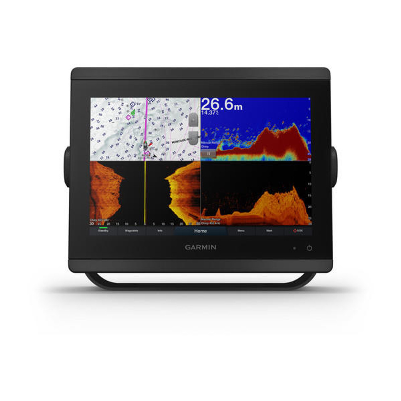
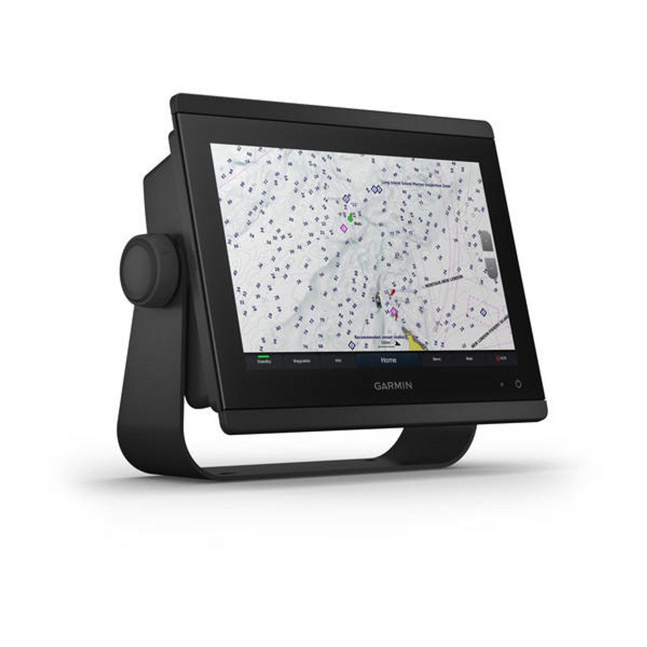
FOR COMMITTED ANGLERS, CRUISERS, SAILORS, AND SAIL RACERS, ONLY THE BEST EQUIPMENT WILL DO. This chartplotter/sonar combo is perfect for serious users and is both simple-to-use and easy-to-install. With 10", 12", or 16" options, the display features wider viewing angles, exceptional clarity and visibility in bright sunlight, and even works with polarized sunglasses. You can easily install multiple displays, either flush mounted or edge-to-edge for a modern glass helm appearance. The optional GRID 20 remote input device allows for effortless remote access and management of your entire Garmin marine system.
Included:
- GPSMAP 8410xsv
- Power cable
- NMEA 2000® drop cable
- NMEA 2000 T-connector
- Bail mount with knobs
- Flush mount kit
- Sun cover
- Trim piece snap covers
- Documentation
Get wider viewing angles and superior clarity on the touchscreen with a full HD in-plane switching (IPS) display.
Navigate confidently with built-in Garmin Navionics+ inland and coastal mapping.
Easily build your marine system using the best of network connectivity.
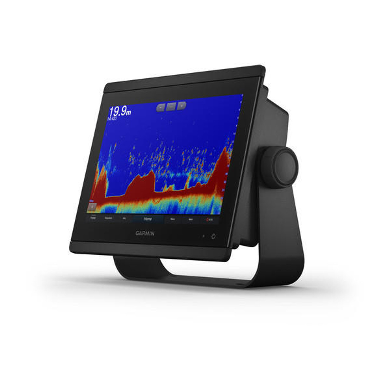
See below and around your boat with built-in sonar capabilities (transducers sold separately)
From ANT technology to Wi-Fi networking, there are countless ways to connect to your system.
With SmartMode station controls, everything is designed to give you quick, one-touch access to the information you need.
Features
- TRADITIONAL AND SCANNING SONAR SUPPORT
Get built-in support for 1-kW Dual-Channel CHIRP traditional sonar for superior target separation and ClearVü and SideVü scanning sonars to see up to 1,000’ below and around your boat at 260 kHz (requires transducer, sold separately). Built-in sonar compabiliity only available on xsv models.
- PANOPTIX SONAR SUPPORT
Pair your chartplotter with Panoptix or Panoptix LiveScope easy-to-interpret live sonar (transducer sold separately) to see all around your boat in real time.
- GARMIN SAILASSIST SAILING FEATURES
View laylines, race start line guidance, enhanced wind rose, heading and course-over-ground lines, true wind data fields and tide/current/time slider, wind angle, set and drift, wind speed and more.
- CHARTS & MAPS
Bring a fresh new look and feel to your chartplotter with optional Garmin Navionics+ or premium Garmin Navionics Vision+ cartography featuring integrated coastal/inland content, access to daily updates, Auto Guidance+ technology and more.
- SAILING POLARS
Use the polar table to see key data, including how fast you should go at a certain wind angle and speed so you know whether you need to adjust sail trim.
- GARMIN MARINE NETWORK
If you have multiple compatible Garmin devices on your boat, you can share information such as maps, user data, radar and IP camera video among them.
- NMEA 2000 AND NMEA 0183 NETWORKS
Connect to autopilots, digital switching, weather, your FUSION-Link audio system, media, VHF, AIS and more from one screen.
- Activecaptain App
Built-in Wi-Fi connectivity pairs with the free all-in-one mobile app for access to the OneChart feature, smart notifications , software updates, Helm, Garmin Quickdraw Community data and more.
- INTEGRATED BLUETOOTH AND ANT TECHNOLOGIES
Connect with some of your favorite devices, such as quatix marine watches, gWind Wireless 2 transducers, GNX™ Wind marine instruments and wireless remote controls.
- ONEHELM FEATURE
This feature brings together all the operations and capabilities of third-party devices, such as EmpirBus digital switching, on one screen.
- SMARTMODE STATION CONTROLS
Get quick, one-touch access to the information you need to ease high-stress situations such as docking. You can incorporate networked sonar, radar, cameras, media and more.
- POWER-POLE SHALLOW WATER ANCHOR
By networking select Garmin chartplotters with a Force trolling motor and your compatible Power-Pole shallow water anchoring system, you can access advanced boat control features from your plotter, including smart anchor auto-deployment, smart anchor jog, auto stow, anchor drag detection and auto guidance end-of-route anchoring. Spend more time fishing, less time positioning.
- CHARGE INTEGRATION FROM POWER-POLE
Your CHARGE Marine Power Manager from Power-Pole integrates with compatible Garmin chartplotters to help keep your battery power going longer and stronger on the water. You’re able to charge batteries on the run, monitor power use, select where power is allocated, control emergency starts and even transfer power between battery banks all from your chartplotter display.
- SEND INREACH DEVICE MESSAGES
Pair your inReach satellite communicator to your chartplotter, and type custom messages using your MFD’s on-screen keyboard. Access your contact list or enter an email, inReach address or phone number. You can also group messages by conversation for a texting-like experience.
Specifications
General
| Dimension | 10.25" x 8.0625" x 2.95" (25.9 cm x 20.5 cm x 7.5 cm) |
|---|---|
| Weight |
5.2 lbs (2.4 kg) |
| Water Rating |
IPX7 |
| Touchscreen | Yes |
| Display Type | WUXGA, IPS |
| Display Size | 8.6" x 5.4"; 10.1" diagonal (21.8 cm x 13.7 cm; 25.7 cm diagonal) |
| Display Resolution | 1920 x 1200 pixels |
| Mounting Options | Bail, flat or flush (Garmin does not offer any hardware or accessories for a flat-mount installation. Professional tools and knowledge is required.) |
| Polarised Support | Yes |
Maps and Memory
| Accepts Data Cards |
2 microSD cards |
|---|---|
| Waypoints |
5000 |
| Track points | 50,000 |
| Tracks | 50 saved tracks |
| Navigation Routes | 100 |
Sensors
| GPS | Yes |
|---|---|
| GLONASS | Yes |
| Galileo | Yes |
| Has built-in receiver | Yes |
| Receiver |
10 Hz |
| NMEA 2000 Compatible | Yes |
| NMEA 0183 Compatible | Yes |
| Supports WAAS | Yes |
Built-in Maps
| Tide tables | Yes |
|---|
Optional Map Support
| BlueChart g3 | Yes |
|---|---|
| BlueChart g3 Vision | Yes |
| LakeVü g3 | Yes |
| LakeVü g3 Ultra | Yes |
| Garmin Navionics+™ | Yes |
| Garmin Navionics Vision+™ | Yes |
| TOPO 100K | Yes |
| Standard Mapping | Yes |
| Garmin Quickdraw Contours | Yes |
| Raster chart support | Yes |
Chartplotter Features
| Smart Mode Compatible | Yes |
|---|---|
| AIS | Yes |
| DSC | Yes |
| Supports Fusion-Link™ compatible radios | Yes |
| GSD Black Box Sonar Support | Yes |
| GCV Black Box Sonar Support | Yes |
| ActiveCaptain Mobile Planning Compatible |
Yes |
| GRID (Garmin Remote Input Device) compatible | Yes |
| Wireless Remote Compatible | Yes |
| Sailing Features | Yes |
| Spoken audio alerts | Yes |
| OneHelm support | Yes |
Electrical Features
| POWER INPUT | 10-32 Vdc |
|---|---|
| Typical current draw at 12 Vdc | 1.5 A |
| Maximum current draw at 12 Vdc | 6.0 A |
| Maximum power usage at 10 Vdc | 40.1W |
Sonar Features
| Displays sonar | Yes |
|---|---|
| Power output | 1 kW |
| Traditional sonar (dual frequency/beam) | Built-in (dual channel CHIRP, 70/83/200 kHz, L, M, H CHIRP) |
| ClearVü | Built-in 260/455/800/1000/1200 kHz |
| SideVü | Built-in 260/455/800/1000/1200 kHz |
| Panoptix™ sonar | Yes |
| LiveScope | Yes |
Connections
| NMEA 2000® ports | 1 |
|---|---|
| NMEA 0183 Input (Rx) Ports |
1 |
| NMEA 0183 output (Tx) ports | 1 |
| Video input ports |
1 (BNC composite); 1 HDMI (HDCP compliant) |
| Video output ports |
1 HDMI |
| J1939 ports | 1 |
| Garmin Marine Network Ports |
2 |
| 8-pin transducer ports | Yes |
| 12-pin transducer ports | Yes |
| USB ports | Yes |
| BLUETOOTH® pairing | Yes |
| ANT® (Connectivity) | Yes |
| Garmin Wi-Fi network (local connection) | Yes |
Get your Garmin GPSMAP 8410XSV Fish Finder Sounder in 3 Simple Steps
-
1
Shop Securely
Place an order with confidence using our secure checkout process
-
2
Order Processing
Allow our warehouse team some time to process your order. Receive order updates via email throughout the process
-
3
Enjoy your gear!
Join over 100,00 other happy Davo's customers. Let us be by your side for all your fishing and outdoors pursuits

About Davo's Tackle


Davo's Tackle and Outdoors Online has become a brand that is synonymous with a range of Fishing and Outdoors products that is second to none; at the sharpest pricing available globally.


Free shipping over $150 excluding bulky items


90 day returns


Fast & Secure payment options


Heavy discounts on big brands


Reputable Australian online retailer


Australian owned for over 40 years


Fish now and pay later


Accurate stock shown on our site
$3,999.00$3,999.00$4,599.00
FOR COMMITTED ANGLERS, CRUISERS, SAILORS, AND SAIL RACERS, ONLY THE BEST EQUIPMENT WILL DO. This chartplotter/sonar combo is perfect for serious users and is both simple-to-use and easy-to-install. With 10", 12", or 16" options, the display features wider viewing angles, exceptional clarity and visibility in bright sunlight, and even works with polarized sunglasses. You can easily install multiple displays, either flush mounted or edge-to-edge for a modern glass helm appearance. The optional GRID 20 remote input device allows for effortless remote access and management of your entire Garmin marine system.
Included:
- GPSMAP 8410xsv
- Power cable
- NMEA 2000® drop cable
- NMEA 2000 T-connector
- Bail mount with knobs
- Flush mount kit
- Sun cover
- Trim piece snap covers
- Documentation
Get wider viewing angles and superior clarity on the touchscreen with a full HD in-plane switching (IPS) display.
Navigate confidently with built-in Garmin Navionics+ inland and coastal mapping.
Easily build your marine system using the best of network connectivity.
See below and around your boat with built-in sonar capabilities (transducers sold separately)
From ANT technology to Wi-Fi networking, there are countless ways to connect to your system.
With SmartMode station controls, everything is designed to give you quick, one-touch access to the information you need.
FAQ
-
-
We are working towards a goal of offering customers the biggest range of Fishing And Outdoors products in Australia. The number of products we currently have available is growing daily.
-
Our customer support office hours are Tuesday only 8am-4pm only. Feel free to use our contact us page to get in touch.
-
We specialise in Fishing, Dive, Boating and any kind of Outdoors Equipment.
-
Yes. We are a fully licensed and accredited Australian retailer for every brand of product that we sell. This means all purchases you are making are made through a fully licensed and registered retailer. More details can be found on our Warranty page.
-
Our inventory and warehouse is directly linked to display accurate stock levels on our website. If you are able to add a product to your cart then we currently have the item available and ready to ship.
-
Sign up for a back in stock notification on the product page to receive an email as soon as a product becomes available again.
-
-
Yes. A few seconds after you place an order you will receive an order confirmation email. Please be sure to check all junk folders.
-
-
We like to keep it very simple. We offer free shipping on all orders over $150 in Australia excluding some bulky items like Fishing Rods. We offer a small fixed rate shipping fee for any order of $150 or less in Australia that does not contain bulky items.
-
We charge a small shipping fee for all bulky items such as fishing rods and other long or heavy products. The small shipping fee that is charged for bulky items will vary depending upon the product.
Our carriers charge us larger fees to ship these items, however we subsidize majority of this cost to provide our customers the best expedience available when shopping for fishing and outdoors equipment online at the best pricing available globally.
-
It is likely that your order contains bulky items such as Fishing Rods or other long or heavy products.
-
Yes. We offer International Shipping on most products to a selection of countries. We don’t offer international shipping on certain products. More details are available on our Shipping page.
-
We are unable to offer an express shipping service.
-
Most orders are sent via Australia Post. Some items are sent via Star Track Express, Couriers Please, Sendle or Aramex. We decide on who to send an order with during the processing stage.
-
We ship a large volume of rods daily and we are proud to say we have refined our shipping technique to ensure all rods are delivered in perfect condition.
Rod are fully insulated with high density bubble wrap. After this, rods are inserted into a purpose built and cut to size rod tube which is professionally capped at each end.
-
We do not offer a click and collect.
-
We ship orders every business day from our warehouse. We have courier pick ups from our warehouse daily.
Please allow an estimated 1 to 10 fulll business days for you order to be processed. Please note this is an estimate only and the processing stage may take longer than this estimate.
After an order completes the processing stage, you will be sent an automated shipment email containing tracking details.
After an order is processed by our warehouse, the courier delivery times may vary depending on the coruier used and the delivery address.
More detailed information on order processing time frames can be found on our shipping policy page.
-
-
We have an ultra simple returns process. All details are available on our returns page.
-
We are more than happy to assist with this. All details are available on our Warranty page.
-
Yes. We are a fully licensed and accredited Australian retailer for every brand of product that we sell. This means all purchases you are making are made through a fully licensed and registered retailer. More details can be found on our Warranty page.